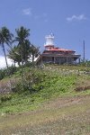


The Lighthouse in San Luis is a historical landmark that signifies Capul’s rich history. The pavilion and tower were built in 1896 by the Spaniards. It was constructed to complement the lighthouses of Isla de San Bernardino and the proposed lighthouse in Isla de Viri. Faro de Punta Capul however was not completed during the Spanish colonial period. It was only finished during the American period by the US Army Corps of Engineers. The pavilion designed in the Victorian Renaissance Revival was slightly modified in orientation and specifications from the original plans designed by Guillermo Brockman. It was made to conform to the narrow and deep topography of the site where it was built. Like most lighthouses in the Philippines, it was situated on an elevated area overlooking an important body of water, the San Bernardino Strait. The lighthouse is 143 feet above sea level and commands a marvelous view. On a clear day one can even see Mount Bulusan in Sorsogon and the Naranjos Islands of Masbate.

It was meant to send beacons that warn ships entering the narrow treacherous waters between the Port of Matnog and Capul. Although it is still operational, the pavilion is badly in need of rehabilitation. Manuel Noche, the author of the book “Spanish Lighthouses of the Philippines” describes its condition to be deplorable. Only the tower has been maintained over the years. The white-washed paint and the orange color of the door frame sadly do not harmonize at all to the “ruined look” of the service building. Being a priority site for tourism development, its rehabilitation is one of the major undertakings in the Tourism Plan.

The “story” of the lighthouse complex goes beyond it’s Spanish and American history. A few meters further down the slope from the main building are three circular Japanese World War II gun emplacements. Big guns used to be mounted there and were intended to be used against the Americans by the Japanese Imperial Navy. Guard railings were installed along the periphery of the 7-hectare complex and along the foot trails as a way to make the area safer to tourists.

Over the edge, one can be amazed by the swift rush of the current washing over the San Bernardino Strait. The rocky shore is often battered by waves that scrape, shape and re-shape the geologic formations. Perhaps this is the reason why “Bigfoot” was formed. This deep indentation on the rocks resembles a giant foot.
1 comment:
Hello I love your Island, I was there last week with a visitor from Senator Gordons Office from Manila, we explored the caves and took a tour of your Island.
I am Promoting Tourism for Northern Samar & the islands, If you would like to see more pictures of your Island that i took, and other Islands please visit www.paradisesamar.com please help me to help you, send me Info, Comments, Links and anything you think may be of use for me to help you to promote tourism, My Name is Steve rice, I am good friends with Chris Bech, I live in Bobon, please email me if I can assist, mrfixitsamar@gmail.com Kind Regards, Steve Rice mrfixitsamar in google search...
Post a Comment